Glacial Lake Missoula
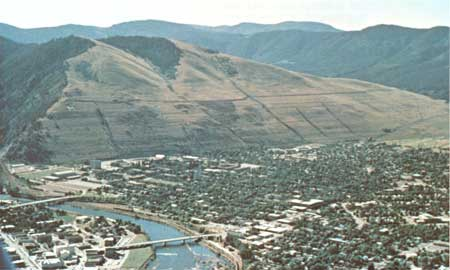
Missoula, MT High Water Mark, Mt. Sentinel, Missoula Missoula, a mid-sized valley town in the Northern Rockies of Montana, has a fascinating geological history. It was part of an ancient ice age flood system over 12,000 years ago. It was known as Glacial Lake Missoula. At its highest, the water level was at 4200 feet in elevation. The remnants of these floods can still be seen today on the sides of Mt. Sentinel and Mt. Jumbo in Missoula, as well as the giant ripple marks on the Camas Prairies northwest of Missoula. I found a couple great websites about ice age floods that talks about what is known and some of the speculations about these great floods, with Glacial Lake Missoula being one. Hugefloods.com --This site has a great video! Glaciallakemissoula.org